
GINA Smart CAD is software for modernizing dispatch processes, including call handling, incident creation, and rapid dispatch of units—ideal for emergency lines, emergency services, and security teams.
It enables dispatchers to make quick and informed decisions, whether it’s day-to-day operations or responding to emergencies. The system ensures smooth communication, clear task assignment, and an overview of all units.

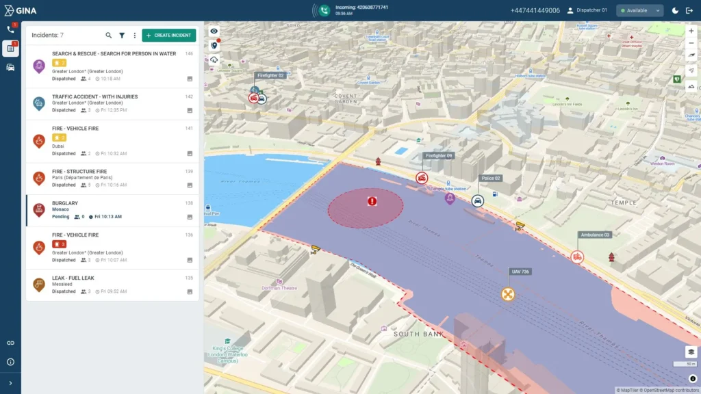
Connection between GINA Smart CAD and GINA Tactical AVL
GINA Smart CAD and GINA Tactical AVL together form one interconnected system.
GINA Smart CAD is the “brain” of the entire dispatch system – this is where emergency calls are received, incidents are created, and responses are assigned.
GINA Tactical AVL (Automatic Vehicle Location) is an advanced tool for tracking the location and movement of units, vehicles, and equipment in real time.
Smart CAD automatically pairs it with the nearest suitable unit, which it knows thanks to data from Tactical AVL.
not as static points, but as constantly updated positions, including direction of movement and speed.
and the system will automatically notify you when, for example, a unit leaves the designated perimeter or enters a dangerous area.
and can be analyzed later – for example, during investigations or process improvements
Features:
- Automatic recommendation – the system automatically selects and recommends the most suitable and closest units
- Situational awareness and visualization – tracking unit positions, live streams, communication with people in the field, map display of incidents, obstacles, points of interest.
- Comprehensive communication – enables chat, voice messages, and multimedia messages between dispatchers, commanders, and field units.
- Clear logging – recording of all steps with time stamps, records for later analysis and reports
- Security – all information between people and devices in the system is protected.
The system is designed to be adaptable to the specific needs of different organizations and to handle large amounts of data and users, for example for:
- Fire and Rescue Service
- Police force
- Armed forces
- Emergency medical service
- Airports, power plants, logistics centers
Frequently asked questions (FAQ)
Smart CAD uses the Tactical AVL (Automatic Vehicle Location) module, which tracks the GPS location of units. Based on availability and distance, the system automatically recommends the most suitable response team.
Yes. The system uses encrypted data transmission (TLS, AES) and meets high security standards. It is also suitable for use in sensitive and crisis environments (e.g., military, civil defense).
Yes. GINA Smart CAD records all activities – including time movements, messages, and events. This data is also available after the event has ended.
Yes. GINA Smart CAD is modular and open for integration – with GIS layers, IoT sensors, hospital systems, navigation (e.g. Sygic), ALI/ANI data, and other technologies.
Partially yes. Mobile applications can work without an internet connection and synchronize later. However, the dispatching interface requires a stable connection to a server or cloud.


